Booking at Ben Nevis
Getting There
Parking
Amenities
Weather
Conservation
Plan your Route
The Mountain – A’Bheinn

Introduction – Ro-ràdh
Ben Nevis is the highest mountain in the British Isles. It rises to a height of 1344m (4409 feet) and for most it is the starting point for the Three Peaks Challenge. Ben Nevis derives its name from the Gaelic, Beinn Nibheis. Beinn is easy to translate it means “Mountain” (you will find a lot of the mountains in Scotland are Ben something). Nibheis is a bit trickier but the most literal translation is “venomous” This should give you a better idea of what you are going to undertake!
Ben Nevis began to form around 500 million years ago when two huge plates in the earth’s crust collided. This started off a mountain building period which created the Caledonian Mountain Chain. These mountains would have been similar in size to the present Andean Chain in South America. During this time great heat and pressure were produced which melted and changed the underlying rock. The molten rock (magma) escaped to the surface and erupted as lava flowing into the area around Ben Nevis. There was also a lot of movement of magma taking place below the earth’s surface which later cooled and created the outer granite. This process reoccurred later which resulted in the inner granite being formed.
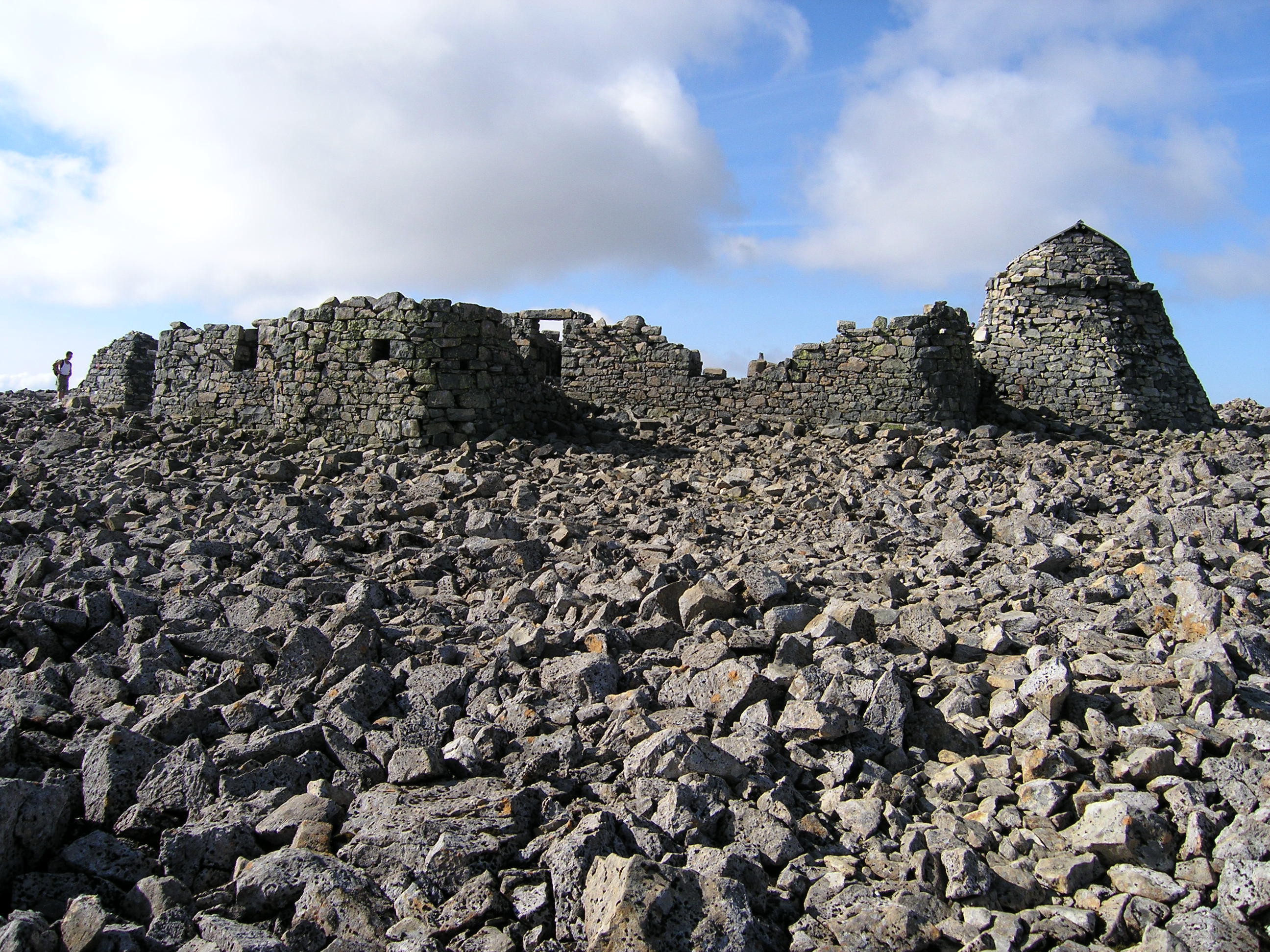
The footpath was constructed during the summer of 1883. The total cost was around £800 for the whole path. It was originally built as a supply route for ponies to carry essential provisions to the men working in the observatory. The observatory was built to record weather conditions at height so that they could be compared with other results taken at sea level. The observatory stayed open almost 21 years, opening in October of 1883 before closing due to lack of funds in 1904.
Environmental Info – Fiosrachadh mun Àrainneachd

Ben Nevis lies within the Ben Nevis and Glencoe National Scenic Area and the Ben Nevis SSSI and SAC. It has a huge range of vegetation types, from lower level woodland to mountain moss heath and semi-permanent snow patch on the North Face. The hill and surrounding slopes are home to golden eagle, red deer, snow bunting, ptarmigan and rare mountain ringlet butterflies. The Ben contains a large number of scarce and rare lichens, which benefit humans by absorbing pollutants in the atmosphere. During longer days the yellow of the bold, four petalled Tormentil and the purple of the late flowering Devils-bit Scabious line the lower path with parsley fern tucked away in rocky hideouts as you ascend further.
Currently there is a North Face Project being implemented by Nevis Landscape Partnership and funded by Heritage Lottery as an on-going exploration of the flora and geology of the North Face. Interesting finds in the first year have already revealed new populations of plants which are extremely rare on this site (one or few other known populations) some of which have not previously been recorded. The project is also mapping the rock types which may suggest how the Ben was actually formed: You can watch a video about this here.
Booking at Ben Nevis
The policy of Highland Council, who oversee the Glen Nevis Visitor Centre, states that all organised events of 10 or more participants are obliged to complete a booking form. The groups are subject to a charge to cover the facilities provided at the Visitor Centre. These include the provision and cleaning of toilets, the hire and use of rubbish skips, the organisation of areas as required. In addition there is considerable time and planning involved ensuring these groups’ dates and requirements can be accommodated. Also the Land Reform Law in the Scottish Access Codes requires all land owners to be notified of sizeable parties crossing their land. Get more info here.
A booking form is available on the Ben Nevis website – which explains the fees incurred and what they are for in more detail. It also informs you of all you need to know about the requirements of large groups accessing the mountain. The website will tell you all about Ben Nevis, from equipment lists to the weather to the piano and car on the top! There is a bountiful history to this very beautiful mountain. We know you are in a hurry but don’t put all that effort in and forget to appreciate for a moment, no matter how brief, that you are at the top of Britain when you stand there and (if you get a rare clear day) take photos!
Getting There – A’ Faighinn Ann
From the South
• Approach Fort William on Achintore Road, A82
• At the West End roundabout take the second exit onto A82
• At the next roundabout take the second exit onto Belford Road A82
• At the third roundabout continue straight into Glen Nevis/ C1162
From the North
• Approach Fort William from Spean Bridge, A82
• At the Distillery roundabout take the first exit onto North Road.
• At the Next (Nevis Bridge) roundabout turn left into Glen Nevis
Parking
Please park at Glen Nevis Visitor Centre pay and display car park (£3 for a car and £10 for a minibus perday.)
Please read our general advice on parking.
Amenities – Goireasan
Litter
At Glen Nevis Visitor Centre we have to provide skips for charity events as there are no bins on site. The mountain however has none of these facilities so take all your rubbish back down with you including food waste because…if it doesn’t grow there, it doesn’t go there!
Mobile Phone Coverage
Mobile phone reception can be patchy and does not work on all sections of the path you can not rely on this for your GPS.
Toilets
We provide toilets at the Visitor Centre opened from 7am till 8pm in the Summer months. Arrangements for toilets to be opened outwith these hours can be made for booked events. There are no toilet facilities on the mountain Please follow the correct guidelines.. Do not use the emergency refuge shelter on the summit as a toilet or to camp. For more information on how to protect the ecology look at our Leave No Trace download on the Ben Nevis website.
Food and Drink
Ensure you take plenty of food and water supplies to last the full day. There are no facilities to obtain these on the mountain. We recommend at least two litres of drinking water per person.
Accommodation
Visit outdoorcapital.co.uk to see a list of local accommodation.
Local Guides
Booking a local guide can take a lot of the stress out of organising your ascent and they will have excellent local knowledge of the area. For more information on local guides click here.
Weather – Sìde
The weather on Ben Nevis can change very quickly. It is essential to know an accurate weather forecast before you set off. We have an up to date forecast at the Visitor Centre in Glen Nevis or you can check for yourself on the MWIS website.
Conservation – Glèidhteachas

Recreationally the mountain has grown and grown in popularity in present day resulting in visitors numbering in the hundred thousand every year. This ever increasing pressure on the fragile environment has had an obvious and detrimental effect on the landscape. The toll of thousands of pairs of ascending feet every year leads to path and habitat being worn away and that coupled with the high rainfall leaves considerable scars of erosion on the mountainside.
The top section of the south facing aspect of Ben Nevis is owned by the John Muir Trust, the rest of Ben Nevis is owned by Rio Tinto (for water rights to the aluminium smelter), both these landowners and Highland Council are amongst the key stakeholders that are part of the Nevis Landscape Partnership who work together to manage the environmental and visitor resources and infrastructure.
Please help us to keep Ben Nevis litter and waste free. Remember…Leave No Trace – Na fàg dad – as do dheidh.
Please consider helping out by volunteering and/or donating.
